PRC · Geodetic Engineering · Est. 1994
RASA
Surveying and Realty
Founded 1994·Nationwide capability·Land · Engineering · Construction · Hydrographic
Prequalification · Capability · Record

The firm consultants call when a number has to hold up in court, or on a bridge deck.

Thirty years of geodetic practice. Signed plans, defensible tolerances, and a register of works you can hand straight to a prequalification committee.

Capability StatementRev. 2026-01
Practice since1994
Works on register1,240+
DatumPRS92 / PTM
Airborne sensorRIEGL miniVUX-1UAV
PCAB / accreditationTo be supplied
PrincipalR. A. S. Alberto, GE
Download PDF ↓
1994
Year of establishment
1,240+
Works on the register
2013
PRC Outstanding Professional
4
Companies under the group
01

The Practice

Five disciplines, one adjusted control network. Every deliverable reconciles to the same datum — so the boundary plan, the bathymetry and the as-built agree with each other.

01.1

Land survey

Boundary relocation, subdivision, parcellary and titling support. PRC-signed plans and technical descriptions.

Lot plans · Tech. descriptions
01.2

Engineering survey

Route alignment, topographic and structural survey for roads, rail, bridges and transmission corridors.

Cross-sections · DTM
01.3

Construction survey

Setting-out, staking, deformation monitoring and as-built verification through the build cycle.

Setting-out · As-built
01.4

Specialized survey

Hydrographic and bathymetric survey of dams, river basins, ports and bridge crossings.

Multibeam · Tidal reduction
01.5

Geomatics engineering

GIS build-out, satellite imagery procurement and long-term spatial data management.

GIS · Imagery
02

Register of Works

The evidence a prequalification committee asks for, in the format they ask for it. Filterable by sector, client type, region and year.

Register of Works — ExtractShowing 6 of 1,240
ProjectSectorScopeInstrumentYear
Central Luzon Link Expressway
CLLEX · Nueva Ecija — Aurora
ExpresswayCorridor topographic, alignmentUAV LiDAR2019
Bataan–Cavite Interlink Bridge
BCIB · Manila Bay crossing
Bridge · MarineHydrographic, bathymetricMultibeam2021
Reservoir & catchment survey
Client to be confirmed
HydropowerTopo-bathy, volumetricsTLS · UAV2020
Luzon grid transmission corridor
Client to be confirmed
TransmissionRoute alignment, ROWGNSS · UAV2022
Port & harbour bathymetry
Client to be confirmed
Airport & portBathymetric, dredge volumesMultibeam2023
Road right-of-way parcellary
Client to be confirmed
ParcellaryParcellary, lot plansTotal station2024
▸ Full register available on request1,234 entries pending client content
03

Instrument Register

Tenders ask what you own. Publishing the fleet is a competitive act — most Philippine survey firms cannot answer this page.

Airborne

RIEGL miniVUX-1UAV

Waveform-LiDAR, 360° field of view, multi-target resolution through dense foliage. SD and LAN-TCP/IP acquisition.

Airborne

UAV photogrammetry fleet

Multi-rotor and fixed-wing platforms for orthomosaic, DSM and volumetric capture. Models to be supplied.

Terrestrial

Terrestrial laser scanning

High-definition survey for structures, tunnels, plant and heritage documentation.

Terrestrial

Robotic total stations

Setting-out, monitoring and control densification. Makes and counts to be supplied.

Positioning

GNSS / GPS

Static and RTK positioning tied to PRS92 control. Base-and-rover and network solutions.

Remote sensing

Satellite imagery

Procurement and processing through DigitalGlobe and Supergeo partnerships.

04

The Group

One masthead, four companies. A client who needs a survey, the instrument to repeat it, the aircraft to fly it and the software to hold it deals with one organisation.

I

RASA Surveying & Realty

The parent practice. Land, engineering, construction and specialized survey since 1994.

The practice
II

RASA Surveying Instruments

Equipment supply, calibration, training and after-sales support for the trade.

Catalogue
III

Drone Vision Pro

UAV platforms and payloads, pilot training and contracted aerial capture.

The fleet
IV

QuantumLab Geosolutions

GIS, spatial data management and the analytics layer over survey output.

Solutions
05

Leadership

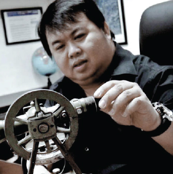
Raymund Arnold S. Alberto, President and Geodetic Engineer
A survey is a promise that someone will build on. We sign ours.
Raymund Arnold S. Alberto · Geodetic Engineer
PRC 2013 Outstanding Professional · President

Core values

Honesty · Integrity · People & Teamwork · Technology & Environment · Quality, Safety & Progress · Business Relationship

Strategic global partners
DigitalGlobeEasymap UAVSupergeoHi-TargetRIEGL

Request the capability statement.

A single PDF with the register, the instrument list, the accreditations and the principal's credentials. Built for prequalification.

Download PDF ↓Talk to an engineer
← All concepts03 · The Bid Book
010203040506 CONCEPT PROTOTYPE